Sam McGee Trail – Yukon – June 22, 2014

You would be hard pressed to find a person not familiar with the name Sam McGee.  Originally made famous by my favourite poet, Robert W. Service, in his poem “The Cremation of Sam McGee”, the poem for many years was part of school curriculum and also read by Johnny Cash on an album he released.  Oddly enough the poem although using the name Sam McGee, was not actually written about the person, Sam McGee.   Sam McGee was originally a road builder who like many others came to the Yukon during the Klondike Gold Rush.  The trail that bears his name is the remnants of a larger trail once used to service the tramway that was built in 1905 by Sam McGee to service the silver mine that he ran.  This information and more (directions to the trail) can be found at:

http://www.yukonhiking.ca/sam_mcgee.html

http://www.robertwservice.com/

One of several old tramways built in the early 1900's.

One of several old tramways built in the early 1900’s.  Windy Arm of Tagish Lake in the background.

The current condition of the trail is wonderful.  It was easy to follow and for the most part dry.  We didn’t have to hike far to start seeing the history behind the trail with old tramway cable and towers visible along the way.  We hiked the trail in late spring so everything was a lush green and snow was still visible on the surrounding mountains.   The trail makes a steady climb to the top with several places to stop and rest to take in the view of Windy Arm of Tagish Lake.  Lupine with it’s purple flowers line the trail most of the way up.  Being a mix of deciduous and coniferous forest there was a wide diversity of plants to see along the way and I have no doubt a beautiful hike in the fall.

Old cable brake.

Old cable brake.

Pickles the dog coming down the trail with Lupine growing on the side.

Pickles the dog coming down the trail with Lupine growing on the side.

At about 4km mark there is a split in the trail (there’s a small split at about 3km that confused us so we were happy to have our gps).  If you take the right trail you continue farther up Montana Mountain which is part of the Mountain Hero biking trail and access the alpine and ridge this way.  We were only doing a morning hike so we went left at the split which took us quickly into the alpine and ended at a panoramic view with an old outhouse and tramway.  You could also access the ridge this way but you would have to find your own path – not too hard to do since you are above the tree-line at this point.   We explored the area for a little while longer before heading back down.

Up close cone picture of what I believe is a Subalpine Fir - beautiful colours.

Close up picture of a cone from what I believe is a Subalpine Fir – beautiful colours.

Remnants of a old cabin.

Remnants of a old cabin.

In total we hiked about 9km with an elevation gain of approximately 620m.  Overall it was a great trail that was very dog friendly and safe for kids.  For anybody that likes trails with a little history this is a great one to try.  I would love to go back in the fall with more time and go right up to the ridge.  As mentioned, this trail is part of the Mountain Hero mountain biking trail so it is not unusual to come across people on bikes, although we didn’t see any.

GPS Track of our hike.

GPS Track of our hike.

Posted in Hiking | Tagged , , , , , , , | Leave a comment

White Mountain – Yukon – June 20, 2014

My boyfriend, Jay, and I decided to take a road trip with our two dogs to the Yukon.  While we were there we did 3 different morning hikes while also doing the tourist things in the afternoon.  Our first hike was Mount White.

After two days driving this was a nice hike to stretch our road-weary legs on.  We had stayed the night before in Teslin which left us about an hour drive to the trail head. The weather was calling for rain but we decided to go anyways and the rain held off all day. Coming from Northwest BC, we are used to hiking extremely wet trails that involve soaked boots and at least one crawl through undergrowth before reaching the rocky alpine.  To be able to hike a trail that was dry and easily followed was a nice change.   Another bonus was not having to share the van with dogs dripping mud when we were finished the hike!

Looking towards Little Atlin Lake

Looking towards Little Atlin Lake

The beginning of the trail is very steep, but quite well defined. Throughout most of the hike, the route follows the power cable for the Northwestel tower atop the mountain. After a short distance we were rewarded for our efforts with a view of the Atlin Lakes.  We continued towards the Northwestel tower that was now visible further up the mountain.  When we came out of the protection provided by the treeline it became extremely windy.  Once we made it to the tower it was so windy that talking to eachother was hard to do and dirt was flying into our faces.  We only made it a little farther past the tower before admitting defeat and turning around.  It was likely for the best as the area is known to have goats with babies around at that time of year.  We could see several not far away and didn’t want to get close enough for the dogs to chase.  The low lying shrubs near the towers were covered in the fur of goats shedding their winter coats.

Looking down the trail from the Northwestel Tower.

Looking down the trail from the Northwestel Tower.

Beautiful Beans Dog enjoying the scenery while leaning into the wind.

Beautiful Beans Dog enjoying the scenery while leaning into the wind.

The way down was easier than up but because it was so steep and often covered in lose rocks, I was regretting not having my hiking poles.  My “old lady” knee was even more regretful.  Fortunately we made it down and out of the wind just as the rain started.  In total we only hiked 4.3km return but climbed about 600m.

Looking North from the tower

Looking North from the tower

GPS map of our Hike

GPS map of our Hike

For directions to Mount White and more information on hiking the Yukon visit:

http://www.yukonhiking.ca/mount_white.html

Posted in Hiking | Tagged , , , , , , , | Leave a comment

Whale Ho!

Kayaking with whales had always been on my list of things to do and this winter I finally got to check it off!  Few people enjoy paddling in the winter but I called up a friend whom I knew would be into a full day of cold paddling and off we went.

It had been unusually cold and dry for this part of the coast with temperatures of about -5C overnight and only warming up to 0 C during the daytime on land, without the wind. Being on the water makes things feel much colder. After struggling with stiff hatches and an icy boat launch at Port Edward we managed to get in the water around 930am. Five minutes into our paddle I tried to lower my skeg.  It was frozen, and stayed that way until the sun warmed things up about an hour later.  Around the same time I could feel something hitting my legs inside of my cockpit. Turns out my “dry” cockpit was just frozen and chunks of ice were falling off and hitting me in the legs – at least things were starting to warm up!

Once of many whale tails we saw.  Usually when you see the tail it means they are going for a deep dive.

One of many whale tails we saw. Usually when you see the tail it means they are going for a deep dive.

Whales spouting in the distance.

Whales spouting in the distance.

With kayaks and fingers thawed out we paddled toward the Kinahan Islands. For several weeks whales had been spotted in the area and we were hoping to get a closer look. Although the tide was not in our favour the wind was and made 3 foot waves to surf us towards our destination.  We didn’t have to wait long for the whales to appear.  I can only assume that these are non breeding whales that decide to stay farther North and feed versus going to Southern waters to have their young.  As we stopped paddling and started drifting everywhere we looked there was whales – lots that were breaching.  I did my best to take pictures, however the choppy water and me forgetting my paddle’s leash made things a bit difficult.  In Canada you are required to stay 100m from the whales and not disturb their path.  We were obviously no concern to them as several times whales came within a couple feet of us, sometimes spraying us as they exhaled.  It was an amazing experience and I was very happy not to end up in the water.  We drifted for over an hour as the whales played around us. The only problem?  I was once again freezing and shivering from lack of movement.  I had lost the feeling in my hands shortly after we stopped paddling and needed to get moving to try and warm up.

This guy came up right in front of the kayak!

This guy came up right in front of the kayak!

We decided to paddle to a beach on West Kinahan Island and stop there in the sun for something to eat.  While we sat there a massive container vessel went by but it did not deter the whales.  Once again warmed up – although my hands still hurt from being frozen – we decided to go check out a noise we could hear that we suspected might be sea lions.

As much as I like sea lions they are by far one of my least favourite things to paddle near.  Some of them are huge and I have had several experiences where they have either hit my kayak, stolen fish off the end of my rod or just over stayed their welcome too close to where I am (or I suppose I was too close to where they were).  To top it off they appear to have very little fear, big teeth and they smell terrible.  The Steller Sea Lions that frequent our coast (which are sometimes considered to be a threatened species) usually appear around March or April but the noise we heard was indeed them.  At first we struggled to see exactly where they were as from a distance their heads sticking out of the water appeared to look like trees branches.  In typical Steller fashion when we were about 150m away they came to see us – without any exaggeration there had to be close to 100 of them.  I was pretty sure they were going to flip us and then eat us but they seemed just to be curious.  As we paddled they would swarm in around us jumping everywhere, making noise and stinking up the place.   I managed to shoot a bit of video but again it was a bit choppy and I was being careful not to get hit by any sea lions.  When we started to paddle home they followed us for almost 2km.  All the time whales were jumping in the background.

Here’s a link to one of the videos:

In total we paddled (or drifted) 22.5km.  Saw countless Humpback Whales, Steller Sea Loins, Eagles and too many other shore and ocean birds to count.  It was obvious that a massive amount of food for these creatures was swimming below us.  Several commercial boats were out fishing and container and bulk carrier vessels were moving in and out of our view.  By far one of the most amazing kayaking days I have had in the Prince Rupert area.  I’m going to be making this an annual trip – despite not being able to feel my hands for several days afterward.

Track of where we traveled.

Track of where we traveled.

Posted in Kayaking | Tagged , , , , | Leave a comment

Work Channel, Quottoon Inlet – September 2008

Work Channel 104

My friend Dallas and I had spent part of our summer 2008 guiding for a company doing kayak tours. At the end of the summer we were dying to do a multiday trip. We were experienced hikers, kayakers and campers but neither of us had done any overnight kayaking trips, we didn’t even have our own kayaks.  Regardless we were determined to go and our boss allowed us to take a couple of his kayaks for our 4 day trip. I can’t remember exactly how we ended up deciding to go to Work Channel, but that was our destination, with a side tour into Quottoon Inlet.

Work Channel can be accessed two ways: via a logging road at the channels end or by boat to the channel mouth. The latter is a couple hours boat ride from Prince Rupert making it hard logistically, so we decided to start and finish our trip at the end of the channel. Where the logging road meets the water is a small bay perfect for launching kayaks. Since we were only going for four days and had kayaks with lots of gear space we didn’t pack light. Steak, potatoes and smoked salmon were just a few of the luxuries that we brought along. However, despite all the space we convinced ourselves that we didn’t need a tent because a couple tarps would do just fine. Just for the record, and for reasons I will explain later, I was all for the tarp idea except I thought we should take new ones.

Day 1

We left the launch shortly before noon and were quickly met with wind. Work Channel is long, narrow, very deep and as we learned, often windy. Our goal for the first day was to make it to the end of Quottoon Inlet about 30km from the launch. With the wind against us forming two to three foot waves we realized immediately that we were going to have to work for those 30km. We hugged the eastern side of the channel and used things like admiring sun stars clinging to rocks as good excuses to take breaks. Most of the eastern side of Work Channel is sheer rock face sometimes reaching close to 100m in height before gradually climbing several hundred more meters. Although this is a beautiful sight it makes for very few areas to pull out kayaks for breaks. In fact I didn’t get out of the kayak for the entire 30km. Once we turned east into Quottoon things were less windy. Quottoon also has towering cliffs with one very narrow section about halfway along. I was told ahead of time and it shows on charts that pictographs can be seen along the narrows at low tide, but we weren’t able to spot them. We headed straight for the shoreline at the end of the Inlet as soon as it came into sight. The giant waterfall would have to wait to be explored tomorrow, we really needed to get out of the kayaks and use our legs for a change. Toon River forms an estuary at the end of Quottoon Inlet offering us a place to pull the kayaks out for the night. We set up our tarps in an area of long grass making a nice soft mattress. A fire was started and food cooked, I happily ate steak, baked potato and corn on the cob. My kind of roughing it! The area was littered with relics of logging days gone by offering a great place to hang our food for the night. We were in grizzly bear country and neither of us had any intentions on inviting them into camp.

Work Channel 040

Relics

Work Channel 042

Quottoon Inlet

Day 2

I woke up very happy that my arms were still working. After a quick breakfast and coffee we broke camp and set out on our way. The sun was shining and the wind was calm. First on our agenda was to check out the waterfall and get drinking water. We neared the falls and Dallas pulled out on the rocks to fill our bottles. This area of the West coast offers a near endless supply of drinking water so fresh that we never bothered filtering or flavouring any before drinking it. I was taking pictures of the falls when Dallas waved me closer. As I paddled forward I soon noticed what he was calling me over for. A seal had pulled itself out of the water and was lying in the sun, on a rock at the base of the falls. It seemed to be as interested in us as we were in it and I managed to get some good pictures before it slid back into the water.

We continued our way out of Quottoon on water as calm as glass. Soon we entered back in to Work Channel, it was far from glass. Our hope was to reach Trail Bay on the West side of the channel so we crossed over right as we came out of Quottoon.  Judging by the wind direction we assumed we would feel less of it on that side. This would have been true if there hadn’t been active heli-logging along the west side of the channel. We passed a camp as soon as we crossed so knew they must be nearby. The channel was worse than the day before compounded by the fact we had to keep going around log booms. Occasionally we would see a helicopter overhead and watch as it dropped massive logs into the boom. I’m sure, given the conditions we were paddling in, the pilot of the helicopter must have been questioning our sanity. The wind was strong enough that stopping to paddle even for a minute made you lose any ground you had gained. I remember counting my strokes to 100 several times trying to distract myself from the pain my body was in. One thing for certain, when forced to paddle in bad conditions your skill level quickly increases and in hind sight it was one of the best things I have ever done for my stroke technique. Needless to say Dallas was in the same situation as me. We both just kept on paddling, nobody complained. After being exhausted with too many boom detours we did a short portage to avoid one. The wind was showing no sign of stopping and we had paddled close to 33km, we admitted we weren’t going to make our destination and started looking for a camping spot. On a shoreline where camping spots are hard to find we ended up having to set up our tarps in the trees, but we were still able to enjoy a fire on the beach along with some smoked salmon.

Work Channel 071

Our friend the seal

Work Channel 096

Dallas filling our water bottles

Day 3 

I woke up in the night to the sound of rain. At first it was a welcome sound, slightly protected under the canopy of trees. Quickly it turned into a typical West coast September rain, steady and at times very heavy. It didn’t take us long to realize that our tarps were leaking. Dallas will never live down the day he told me that the tarps we were bringing didn’t leak and that we didn’t need to bring the new ones that I had.  As a result we were a bit damp when we woke up in the morning. Due to the heavy rain and continuing wind we decided not to break camp, we would paddle farther down the channel and return to our site later that day. After breakfast and some rearranging of tarps to ensure our sleeping bags weren’t going to get wetter, we set out. We paddled 10km further down channel making our total for the day about 20km. The rain and wind were steady all day but we made the best of it by practicing our hand-lining and managed to catch a few fish in the process. Dallas was much better than I, catching us some rockfish to cook for our dinner. We attempted to rearrange our tarps so that we would be able to have a fire and still sit undercover but Mother Nature was winning that evening. There was not a dry piece of wood in the forest. We piled gathered wood around our fire in an attempt to dry it before burning to reduce the amount of smoke. Several times we were smoked out and only saved by the “best homemade fire-starters ever”. Neither of us had any dry clothes, our eyes were blood shot and swollen from smoke, but again nobody complained. That night we slept wrapped up in the bottom tarp to stay dry. Every time one of us moved the tarp made so much noise that it woke the other person up. The rain continued all night.

A very wet day

A very wet day

Day 4

Today our goal was to make it back to our vehicle. It was the final day of our trip, and with it still pouring rain while we packed we were looking forward to be heading home. We thought we would get lucky today and have the wind at our backs, but the rain had settled in so much that all the wind had blown away. At least the water was calm. We had only been paddling for a couple of hours when the rain stopped; at times we could even see the sun. We took turns towing each other on the way back so the other person could fish – teamwork at its finest. Often seals would pop up to see if we had caught anything. In the end we had a couple fish to take home with us. We landed on shore mid-afternoon after paddling just over 32km. The tide was on its way out so we were able to pull everything out of the kayaks without fear of things floating away. I brought the truck down and we started getting everything loaded. Not long after bringing the truck down we noticed that the seals weren’t the only critters interested in our fish. Along the shore coming towards us was a young grizzly bear. As it came near we shouted at it and fired a bear banger to which it didn’t flinch. Luckily, it must have been on its way to better things as it trotted on by and could be seen for some distance still travelling the shoreline. Finally we got everything loaded and crawled our way back down the logging road to the highway.

Our friend the bear

Our friend the bear

Map of our trip

Map of our trip

Looking back Dallas and I still consider this a great kayaking trip. At the end of every day we hurt, and Mother Nature wasn’t giving us a free ride. We both wished we could have stayed longer. I ended up buying a kayak within a couple months of this trip. Work Channel and Quottoon Inlet have some absolutely gorgeous scenery and excellent fishing. Although we didn’t see any (but did hear one) the area is frequented by whales. There are also a few float camps in the mouth of the channel that offer rooms for rent. To find more information on accommodations visit www.oceanwild.ca. I haven’t kayaked this area since our trip in September 2008, but it’s about time to do it again. Dallas has completed this trip since, coming out of the mouth of the channel and paddling back on the outside down to Prince Rupert, not visiting Quottoon Inlet. Together we have completed several other multi-day trips, each time having a great experience and bringing tents.

Posted in Kayaking, Uncategorized | Tagged , , , , , , , , , , , , , | 4 Comments

Mount Oldfield Trail

IMG_7129

I have hiked the trail to the top of Mount Oldfield several times. It’s part of an old unmaintained trail system that used to link Mount Oldfield and Mount Hays as well as the chalet (now burned down) for the no longer existing ski hill. I often wonder what Prince Rupert must have been like back in its boom days and I’m curious to see if the up and coming “boom” will result in any form of new outdoor recreation funds to help get some of these long deteriorated trails back in proper condition for use.

Even in its current condition I find this trail enjoyable. It’s close to town, and with only a 500m elevation gain and just less than 10km round trip, it’s easy for me to complete before my 4pm work shift. I normally park on the shoulder of the road near where the trail starts. At this time of year (and in the spring/winter) overgrown boardwalk is noticeable from the road, marking where the trail begins. I geared up the dogs with their packs and started up. I’m still on the fence as to whether it is better to use the boardwalk or safer to walk in the bog it is partially covering, I usually do a little bit of both. On this particular day frost was covering the already slippery boardwalk so bog was my preferred choice.

For the most part the trail is straightforward, a steady climb to the top with two trail intersections to navigate. There is also a cleared area near the beginning where the hydro lines run that can make it hard to stay on track. Staying a bit right when you enter the clearing you can see remnants of boardwalk which mark the trail. The first “T” in the road offers a way to a trail called the Tall Tree, at this point you want to stay left. The next “T” offers a link with Mount Hays and where the chalet used to stand, at this junction you want to stay right. Other than that it’s just your typically rainforest hike; a few trees to climb over and a few to crawl under with many streams and boggy areas in between.

Most of the major streams have old wooden bridges crossing them. One bridge was surprisingly sturdy, but it’s still a good idea to walk on the edge of the planks where it is supported by logs rather than taking the chance of having something give way. In several places fallen trees have been cut to be used as stairs, these, like the boardwalk are use at your own risk. Although the trail doesn’t offer any great panoramic views at the top there are some notable features along the way.

Sturdy old bridge missing its railings

Sturdy old bridge missing its railings

Beans the dog with her pack navigating the "stairs"

Beans the dog with her pack navigating the “stairs”

Interesting fungi growth.  You can see how the growth pattern changed after the tree fell down.

Interesting fungi growth. You can see how the growth pattern changed after the tree fell down.

Several very large cedar and spruce trees can be spotted on the hike, not old growth, but they are likely to be second growth. Lots of fungi, ferns and nurse trees can all be seen playing their role in the forest. I even found a couple of Violet Cortinarius mushrooms that aren’t as common in our area. One thing I particularly enjoyed this time was the frost. I’m not sure if there is a particular name for it but when water logged branches start to freeze it causes the water to expand. As the water is pushed out of the branch it freezes, creating a frost that look like lengths of grey hair. I see this often in our area where everything is saturated with rain and temperatures typically dip below freezing only during the night. I was happy to have my camera with me this time. One other thing on today’s hike made it different from the others.

Natures beautiful frost

Natures beautiful frost

After taking a look at the peek-a-boo view at the top a visitor joined me. It caught me off guard at first, all I heard was the swoosh of the wings as it flew by my head. It was a raven. It is very common to see ravens in our area but this one was acting weird. It stayed very close to me, often landing in trees a couple arm lengths away. Just as soon as I thought it was gone it would buzz by my head screaming some incoherent bird talk on the way by. It wasn’t acting aggressive, but it wanted to be noticed. It kept this up for over an hour as I made my way back down the mountain. Many cultures believe that birds carry the spirit of the dead over to the afterlife. I sadly lost a friend in an accident only days earlier and as the bird followed me around, even though I don’t usually believe in these things, I couldn’t help but wonder if it was him. Nearing the end of the hike the raven made one finally dive near my head and took off. If nothing else it is always enjoyable to have interactions with wildlife, even just a bird.

View from the top

View from the top

One downside to this trail is there is a lot of devil’s club. Combine that with some overgrowth taller than me and I recommend not doing this trail in the summer. Spring and fall are preferable and winter can be great as well just don’t forget to pack your snowshoes!

Trail to the top

Trail to the top

Posted in Hiking | Tagged , , , , , , , , , , , , , , | 1 Comment

Mount McLean Trail

IMG_7050

My dogs, Beans and Pickles, running at the top of Mount McLean, looking west at the Skeena Valley

Mount McLean is approximately 65km east of Prince Rupert.  When travelling towards Rupert, it is a very notable mountain with a large eroded cirque formation reminding us of the glacier that once existed.  Surrounding the central bowl are three peaks, each topped by communication towers or beacons.

It took me a long time to figure out this trail existed.  I managed to track down a little information from the Terrace Hiking Group and more info from people I know.  Based on many other hikes, I assumed it would be no different than any other trail near Prince Rupert: wet, slippery, unmarked, and overgrown.  If the trail wasn’t easily identified, my plan was simply to head up – after all I was trying to get to the top of Mount McLean.

The trailhead is across the highway and railways track from a rest stop, making parking easy.  The rest stop is at an area known as “Telegraph Point” but for me it was easier to note that it was adjacent to Scotia Creek. As I expected, the trailhead was hard to find but a close inspection revealed a tiny piece of flagging tape in a spruce tree across from the grassy section of the rest stop.  I’m pretty sure I picked the perfect day to go; it hadn’t rained the day before so things were as dry as they come in our area.  It was late enough in the fall that summer foliage was gone making it much easier to see the trail, plus the sun was shining!  Right near the trailhead a warning was posted stating that the area could contain unexploded artillery shells used for avalanche protection and if found shouldn’t be handled.  I didn’t find any.

IMG_6979

Small creek crossing.

With the exception of the hydro-line section, the trail to the tree line was easy to follow and relatively well marked.  Some parts are rather slippery and wet and there are a couple of small creek crossings that I’m sure with the right timing are not so little.  Parts of the trail are an amazing green with mature trees and lots of mushrooms on the ground.  This is my favourite type of trail to hike.  Several trees were down on the trail and crawling over and under was necessary.  One area was particularly steep and I had to lift my one dog up and over the ledge and then help her down again on my return. 

View from the helipad.

View from the helipad.

The hydro-line section was rather difficult to get through, but if you cross over, stay high and aim yourself for the helipad visible in the distance it isn’t too bad.   On my way up I decided to cut into the trees to avoid having the dogs cut their feet on the slash, this ended up being a mistake.  The area right above the hydro-lines was full of blow-down and hard to navigate.  I suggest just staying on the existing trail for this part of the hike.

IMG_7062

Looking east at the Skeena Valley

The tree line has an elevation of about 350m which takes just under 3km to reach on this trail.  At this point things become typical West coast boggy alpine. However, the amazing views of the Skeena River and Coastal Mountain range with its unique folds and smoothed tops soon make you forget about any wet feet you might have.  Once out of the tree line I immediately spotted goats on the farthest North peak.  The trail more or less disappears here with the occasional faded flag marking a path.  I was interested in taking a closer look at the cirque formation found on the southern most peak, so I made my way to that area.  The higher I climbed the colder it got and a light dusting of snow was already topping the mountain.  Steps had to be taken carefully as many rocks were covered in ice.  Just over 2.25km and another 800m plus of elevation gain I reached the top of the southern peak.  Skeena Valley can be seen east to west with the Kwinitsa Valley visible to the northwest and Scotia Creek Valley to the South.  The pair of eagles I was looking up at earlier, were now below me.  From here you have the choice to continue to the other peaks or go back down.  I explored the area for about half an hour and came back down the mountain.  Early November in the north doesn’t offer much for light after 4:30pm, especially under a canopy of mature trees. 

Radio Towers to the north.

Radio Towers to the north.

I hurried my way back down into the tree line just as the sun slipped behind a mountain, leaving me just enough time to get back to my vehicle before darkness.  My trip was about 11km return with an elevation gain of roughly 1100m.  Overall Mount Mclean is ranking as one of my top 3 favourites in the Prince Rupert area and I can’t wait to go back up and explore the other peaks. 

Mclean

GPS track of my hike on Mount McLean

Posted in Hiking | Tagged , , , , , , , , | Leave a comment

Wesach Mountain Trail

IMG_5914

Well, today I attempted Wesach Mountain for the second time.  Armed with the knowledge of which turn to take and a promising weather forecast, I loaded my dogs, Beans and Pickles, into the truck and off the three of us went.  I had barely started up the logging road when the promising weather forecast turned out to be wrong – big surprise.  It was very overcast with bouts of rain every now and then.  I crawled up the logging road appreciating my little 4×4 and thinking that people with no understanding of 4×4 and those lacking the ability to change a tire should not attempt this.

It wasn’t long after this thought that I heard a crashing sound from the back of the truck.  The dogs were in the back which is covered by a canopy.  Beans finds it rather amusing to attempt to grab trees as the branches come close to the window, usually by the time I get to the top of a logging road the back is filled with twigs and leaves.  This time I closed the side windows so she couldn’t play her little game.   When I looked in my side mirror and saw her snout I immediately knew what the crashing sound was, a broken window.  I suspect the brick head of a dog broke it trying to catch a tree.  Obviously I had to stop the truck and check things out as I was afraid she might cut herself.  The window had broken into hundreds of tiny pieces and glass covered the bed of the truck.  I unloaded the dogs and everything else out of the back and used cedar bows to sweep the glass out of the back.  Did I mention the truck was listed as “For Sale” two days earlier?  Thanks Beans!  Everything was loaded back into the truck and I continued up the road.

At about the 6km marker I turned onto a spur road for about a kilometer and then pulled over where there was space to park.  I wasn’t exactly sure where the trail started but I knew it must have been close.  Luckily there was a sign reading “Wesach Mountain Recreational Trail” a couple 100 metres from where I parked. The trailhead started at about 1000m and if it hadn’t been so foggy I’m sure the view would have been spectacular.  The trail started to climb immediately and after a short distance through some slash I was into the trees.  This area is often shrouded in a misty cloud making the forest a gorgeous green.  A type of lichen commonly known as Old Man’s Beard hung from almost every tree and branch.  Moss covered the entire forest floor except where the tread of boots had worn a single path.  Many types of fungi dotted the mossy ground and trees.  The trees were mostly mature and well spaced making it an ideal obstacle course for the canines.  This section of trail was very easy to follow and the steepest sections had rope tied to trees to assist in the climb.  I find rope far more useful coming down than going up. In less than an hour I was out of the trees and into the rocky alpine.

Image

Trail through the trees.

Image

One of many fungi pictures.

At almost 1400m you would expect to have a bird’s eye view.  Unfortunately, most of the time it was hard to see more than 30 ft due to the weather.  There was a constant shift in the cloud cover and every so often I would get a glimpse of the view.  As soon as it would appear to be clearing up a cloud would start to form in the valley below and quickly rise up and surround me, often bringing rain with it.  It was a battle between trying to take pictures and getting the camera away fast enough to keep it dry.  The trail is a bit difficult to find when you first come out of the trees but easy enough to get back on track if you lead yourself astray.  It is very clear where you need to go once you get on the ridge, up!  It becomes more of a scramble as you go higher.  No mammals spotted today but lots of whistling marmots, birds and no end of unique flora and fungi.  I’m upset to say I didn’t make it to the top once again.  I could see on my GPS that I didn’t have far to go, but the rain was making things very slippery and for the most part the fog was so socked in that I couldn’t even see the top, nor would I be able to enjoy the view when I got there.  Since I was travelling alone (except for the dogs and I don’t think they will help me if I break a leg) I thought it was best to turn around.  My elevation was about 1600m when I turned around about ¾ of a kilometer to go from the top but with 350 more metres to climb.

Image

Looking down at Kalum Lake

Image

Foggy starting up the ridge.

After some slipping and sliding down the trail and several stops to eat the multitude of berries along the way I made it to my truck.  It took me an hour to get back down the logging road (with no more smashed windows) and back to my garden, where I usually have a view of Wesach Mountain.  A few hours later the cloud finally broke and the mountain came into sight, but only for ½ an hour before being swallowing back up again.  I was happy with my decision to turn around and now have yet another excuse to go back up.  This trail is a bit difficult to get to, but is very enjoyable and highly recommended.  The steep sections at the top made me a little nervous with the dogs as I wasn’t convinced they wouldn’t fall off the edge, something to think about if you ever decide to go.

I know Beans the dog has started her own blog.  I suspect in the next couple of days she will be telling her side of the window story.  To read her blog go to http://dogdiaryblog.wordpress.com/.

Image

Google Earth map of the road and trail.

Posted in Hiking | Tagged , , , , , , , | Leave a comment

Estevan Group of Islands, Estevan Sound and Campania Island Kayaking Trip

The Pre-trip – Before any great adventure comes a great amount of planning.  For some this is horrible, but I personally love it.  I probably put almost as much time into the planning phase as the trip itself.  The main points of planning are: what to eat, where to go, what gear to bring, and your safety net back in civilization.  Food planning although time consuming, is relatively easy.  Bring things that don’t spoil, that are easy to cook, or that don’t need to be cooked at all.  We dehydrated all of our own veggies and most of the dried fruit that we brought along.  Pasta, rice, nuts, oatmeal and beans were other staples that rounded out our meals.  I have learned in the past that having a really good meal can turn around an absolutely horrible, windy, rainy day.

Deciding exactly where to go is likely the most difficult thing to do.  There are so many places to see and only a limited amount of time.  I try to find nice beaches to comb and camp on with a good balance of paddling and of course a nearby fresh water supply.  Even in the worst conditions that I feel comfortable paddling in you can still easily make a good 20km.  Tides of course must be taken into consideration and tides charts should be brought along and checked regularly.

Gear for kayaking has to be useful, light, and compact.  Layers are important and you can never have too many dry-bags or matches.  I find that keeping in touch with people in civilization is more for their peace of mind than mine.  We used a spot messenger for semi-daily check-in and a VHF radio for weather and emergency communication.  Once you have everything planned down to the last detail you can throw it all out the window as the weather is going to determine literally everything you do!  We ended up with about 300-350lbs of “stuff” plus two people when we started out.  Coming back, we weighed about the same when you take into consideration all the treasures we collected.

IMG_5019

Day 1, July 2, 2013 –  We left Kitimat’s MK Marina in “The Big O”, a 32 ft orange former navy zodiac.  We had a full load headed out with myself, Jay, Marc and his 3 girls Sophia, Hazel and Iris, two 17ft kayaks, 8 days and 7 nights worth of gear and food for the two kayaks, a 9 ft inflatable zodiac plus two days of supplies for Marc and the girls.  Our straight run from MK to Ethelda Bay (about 2.5-3 hrs), closely followed the proposed route the oil tankers would be taking.

Unfortunately, the dock that once existed at Ethelda Bay is no longer.  We were unable to tell if it broke free from the pilings during a storm or if it was dismantled.  When I was first at Ethelda bay in 2010, part of the dock was already falling into the ocean.  Due to the lack of dock we tossed the kayaks overboard and hauled things to shore.  We tied the big zodiac to what proved to be two anchored logs and then used the little inflatable boat to come to shore.  Once everything was organized we quickly hiked over the island to catch low tide at the white-sand beach on the west side.  This beach once produced a very large green glass float so hopes were high but no luck was had this time.  We did, however,  find several large non-glass Japanese floats, two floats from China, a large piece of bamboo and endless amounts of foreign garbage and bottles.  After returning from our hike we set up two tents on the remaining boardwalk and had an early night.  Dinner consisted of veggie burger and rice wraps.  Tomorrow morning the real adventure begins.

Note:  Ethelda Bay-Tennant Island Conservancy was designated as a conservancy on May 31, 2007 following recommendations from the North Coast Land and Resource Management Plan. Ethelda Bay was the site of a former manned radio beacon station (operated by the DOT, Ottawa) where a maintenance crew was once housed. A private couple purchased the houses, dock, generator station, and helicopter pad from the federal government in 1996 to develop a tourist and fishing lodge.

http://www.gent-family.com/radiohistory/chapter3a.html

http://gentfamily.com/EtheldaBay/etheldabay.html

Image

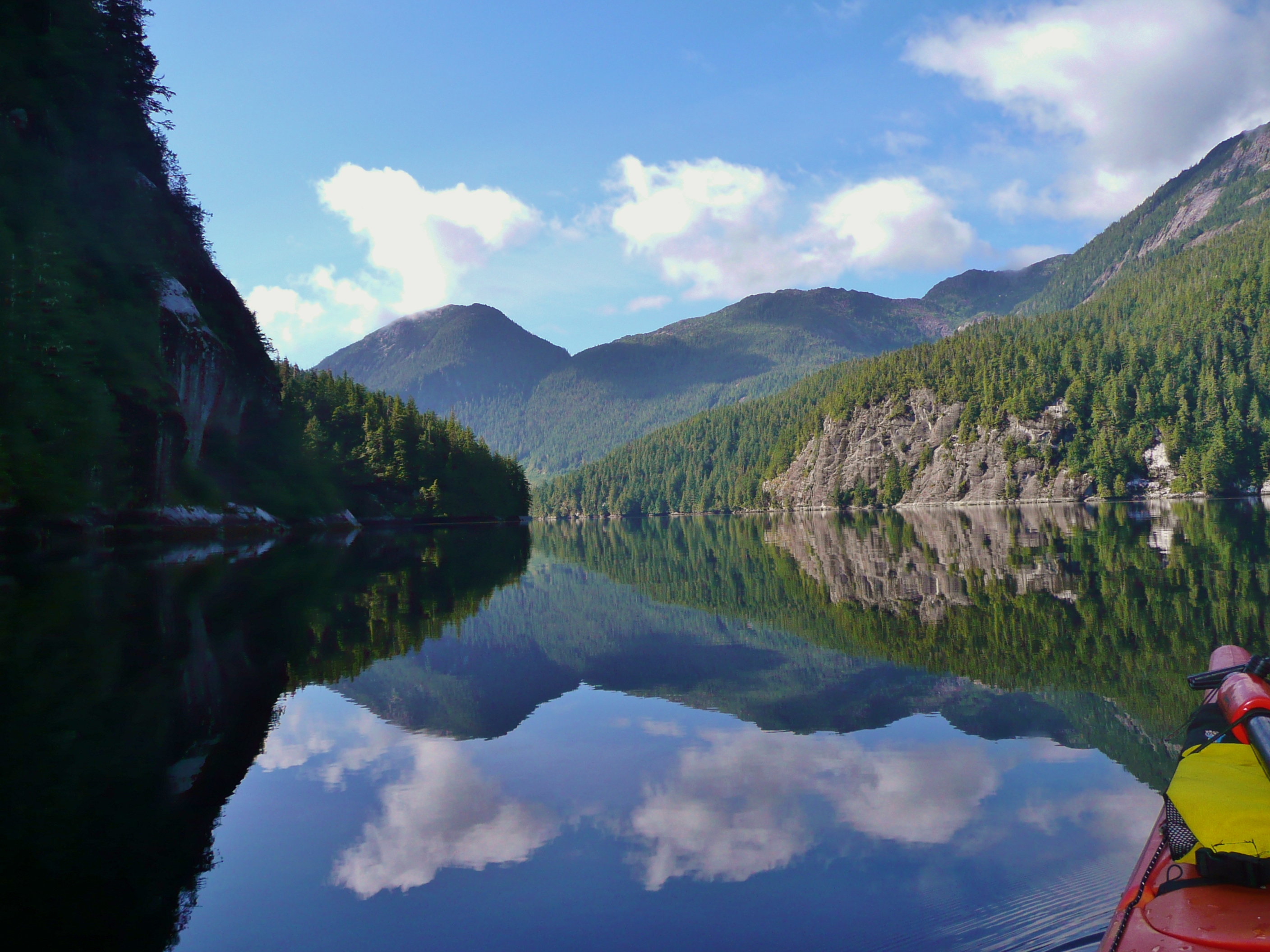
Day 2, July 3, 2013 – Hitting the water at about 8am everything was dead calm.  Little did we know this would be the calmest we would see the water.  We paddled slightly east, and then north, before creeping west through a quick flowing channel out to open ocean.  The tide was already on its way up when we popped out the other end of the uncharted channel, waves were crashing on rocks and reefs all around us.  We stayed a safe distance from shore and snaked our way towards our first destination where we set up camp.  The distance was about 10km and it took us about 2 hours.  We chose a site that was tucked out of the wind that didn’t have too large a sand bar to deal with at low tide.  After setting up camp we decided to investigate the beach around Oswald Bay which was only a short paddle away.  We beachcombed the entire beach and circumnavigated the island that is connected at low tide.  I found many treasures including several plastic floats that I towed back to camp and no end of seashells, but no glass floats.  For those who don’t know I am obsessed with finding glass floats and more or less planned this trip so we could find some and bring them home.  While on our 4-5 hour beachcomb we took a closer look at the uncharted pass between Dewdney and Barnard Island.  We will have to make our way through this pass on Day 4 and hope that we have a high enough tide to do so. The Tide had gone out while we beachcombed and the white sand beach around Oswald has a very gradual slope leaving us a decent portage to get back to the water.  Upon arrival back at camp we found fresh wolf tracks.    In the evening we had fire roasted asparagus and mushrooms with spaghetti and cheese.  An old, large, washed up log served as our kitchen.  As a precaution, even though I was 99.9% sure we wouldn’t have a problem, we hung our food to deter any possible critters.

Image

Day 3, July 4, 2013 –We departed in the morning around low slack tide.  Most of the day consisted of paddling shoreline and over 10km of beachcombing.  Can’t believe we didn’t find a glass float after hours and hours of searching.  We towed two more large floats back to camp despite a very strong headwind making it nearly impossible.  The forecast is calling for the winds to continue and increase to Gale force winds for the next few days.  We saw a couple pairs of huge sandhill cranes today and one lone wolf.  I suspect it’s the same wolf that made its way through our camp.  Tonight was rice, beans and veggies for dinner.  We will be packing up in the morning to move camp to the inside of the Estevan Group, hopefully getting through our nearly dry passage.

Image

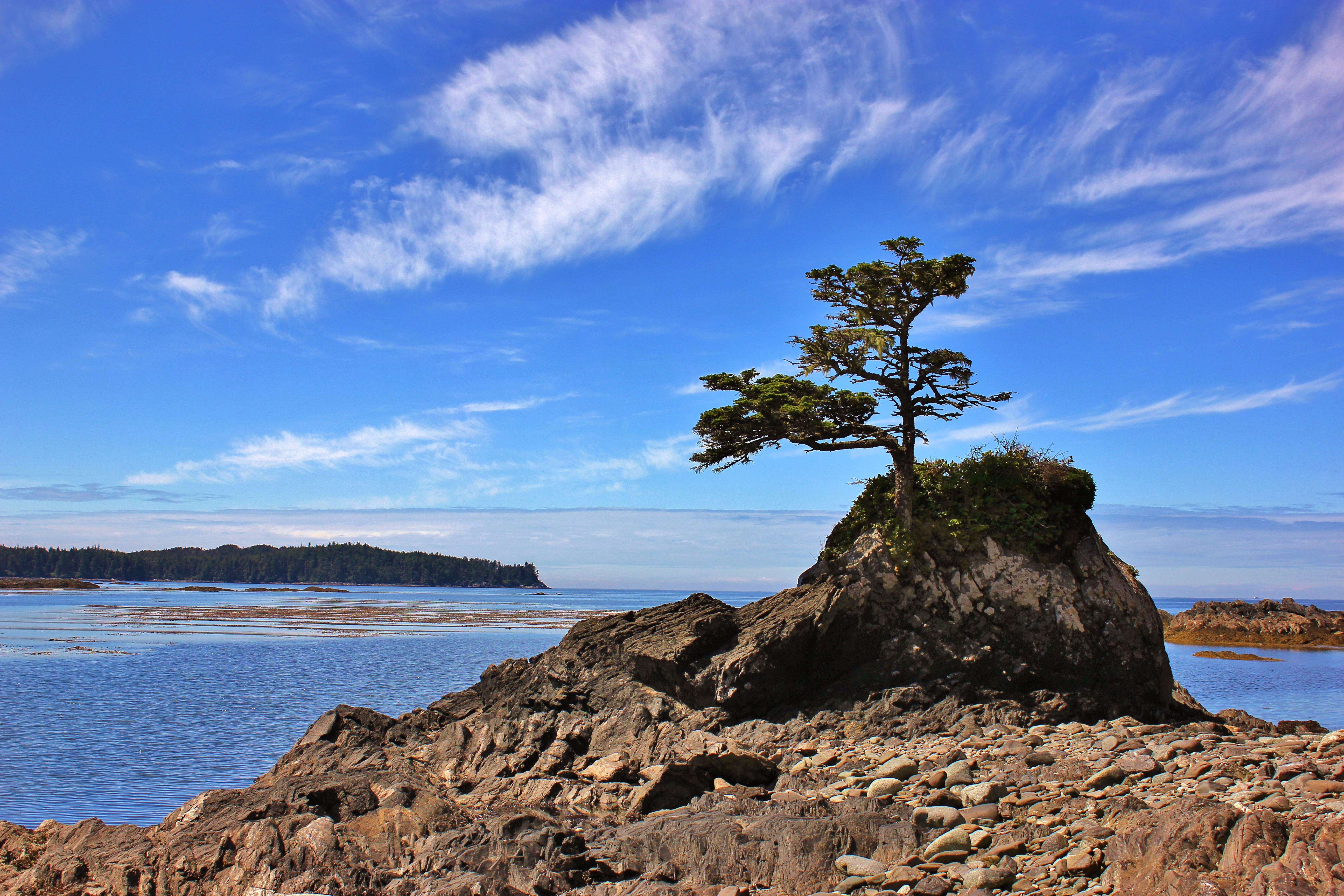
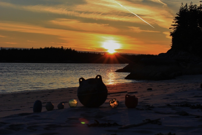
Day 4, July 5, 2013 – Windy!  We were up early and broke camp.  The winds had really picked up overnight making it impossible to paddle around the tip of the channel that we needed to enter and causing breaking waves on the beach where we would have to wait for high tide.  As an alternative we opted to portage about ½ km making completely emptying and repacking the kayaks a task completed several times today.  Once we had the kayaks on the other side of the portage and back in the water things were smooth sailing, literally.  The Gale force winds were at our backs and we were reaching speeds of 10km/h without actually paddling.  We saw a white sand beach about halfway to our destination so decided to pull the kayaks out and take a look.  It was a small island that we now refer to as Carcass Island due to the mummified wolf we found washed up on shore.  We walked around the island and found many plastic floats and other debris.  Jay also found one small GLASS FLOAT.  It was buried in a rock pile and still had netting around it.  I was extremely happy.  Back in the kayaks we climbed, content with our treasure and many pictures of Carcass Island.

Not much further along we spotted several seals out on the rocks trying to figure out what we were.  Now paddling on the east side of Lotbinière Island we could look across Estevan Sound.  We pulled into a sheltered cove and started making dinner.  As we fired up the stove and added the ocean water to the pot in preparation for pasta, we realized we no longer had cutlery.  Two spoon and two forks will now be somebody else’s treasure at our first campsite.  Sea water works great for cooking pasta, but is a bit too salty for rehydrating veggies.  Jay solved our utensil dilemma by creating some west coast style chop sticks made of drift wood.  They worked great!

After dinner we still felt energized as most of our “paddling” today was floating.  We thought we might have time and energy to attempt our 8km crossing this evening.  We entered Estevan Sound and encountered 2-3 meter swells with a strong North wind.  The swells were spaced so the bow of the kayak would ride down one swell and go straight through the middle of the next leaving us rather wet.  It only took us a few minutes to decide that this was not ideal and retreated to find a campsite for the night.  The East side of the island is very rocky so finding a beach to camp on was difficult, instead we chose a rock that we hoped wouldn’t be hit by the 17ft tide.  After tying everything down for the night we counted on things calming down enough for us to cross in the morning.  Low slack was at 7 am.

Image

Day 5, July 6, 2013 –I could tell by the tent flapping all night that the wind had not died down and when I peeked my head out I could still see a large swell and choppy white water.  I decided it would be best to continue napping and try again later in the day.  Overnight, the water had crept up within 3 feet of the tent and the wind had tossed our kayaks up on the rocks.  The wind let up a bit by mid-morning and we decided things looked ok to cross.  We started out about 1130.  There was about 1m swell with 2 foot wave but overall was an easy crossing considering there was still a wind warning.  We paddled mostly north and travelled almost straight east, completing the 8km trek in about 1.5hrs.

Campania Island greeted us with lots of white sand and we picked a big white beach to set up camp.  We hoped to spend 3 nights here.  We easily found fresh water and quickly filtered and restocked our supply.  Although this area was beautiful it was obvious that we weren’t the only ones around, an odd feeling since we hadn’t seen a soul for several days.  Much more beachcombing was done today and Jay once again sculpted more fabulous chopsticks for dinner, clam shells have been working great as spoons.  No rain to be seen since we started our journey and none in the forecast.  We are both feeling rather crisp.  Late that night I could hear the waves rolling on the beach.  Although the kayaks were tied up I didn’t want them soaked for the morning so sent Jay out to pull them up.  He came back to the tent telling a tale of small plate size objects moving on the sand.   He didn’t have his glasses on so he wasn’t sure what they were.

Image

Day 6, July 7, 2013 –  Super low tide this morning making it easy to explore the intertidal zone; which I did for several hours.  I could see tracks which appeared to be frog coming from the forest to the high tide mark.  I suspect this is what Jay saw on the beach but I am definitely going to stay up late tonight to find out for sure.  We paddled south down Campania and stopped at every beach we could.  The farthest beach we went to had an unusually high amount of sponges washed up on shore, likely because of a big storm.  We also found another huge plastic Japanese float which I attempted to tow before having to let it go.  The last beach we stopped at seemed to go on forever and because tide was on its way out, about 200ft of pristine sand was exposed.  Buried in the beaches bank, another glass float was found, oh happy day!  We noticed a research coast guard vessel yesterday as it headed into McMicking Inlet.  Today they came for a visit after dinner;  it was a bit odd to see people again!  We had a fire and found out they were all from Victoria and up here re-charting some areas.  Just before dark our mystery creatures appeared and we confirmed they were indeed frogs.  From what we can tell they come from the forested area at night to eat sand fleas at the tide line in the dark and return before morning.  They seem to be a favourite snack among Campania wolves.

Image

Day 7, July 8, 2013 –   Pancakes.  Delicious, delicious pancakes.  Now, really pancakes are not that big of deal, however, when you have no utensils and a stove that only has one setting then pancakes are something to be proud of.  We even had butter and maple syrup to complete the yummy meal.  Today we finally saw our first whale!  Jay seems to scare the whales off; I have never paddled this much and seen so few whales.  It was a lone humpback that spent all day in the sound.  We watched him for some time with him coming pretty close to us.  We paddled north today which figures as the wind had changed direction and was now coming from the south so our paddle back was somewhat challenging.  Not as many beaches on the northern stretch of Campania’s west side but there were some very unique rock formations and we did find one overturned aluminium boat washed up on shore.  The wind calmed down tonight and we had a fire and dinner while watching the whale continue to feed.  The coast guard and survey crew stopped by again tonight.  Paul was the skipper, Craig was the main surveyor, and Josh was a surveyor in training.  Based on the weather we decided to stay camped at our same place and figured Marc could find us tomorrow.  We had been sending out two spot messages a day which included our coordinates so as long as he has been receiving those he will know where to find us!  A week has gone by way too fast!

Image

Day 8, July 9, 2013 – Back to civilization we go.  We woke up early to pack up camp and wait for our ride.  I wasn’t sure what time to expect Marc but I knew we may have to hurry getting things onto the boat once he got here so I wanted to be organized.  It was yet another gorgeous day, last night was our first time this trip getting any rain.  Even so, it was barely enough to get the ground wet.  We had everything ready to go by 10am.  We could hear boats coming from miles away and when we heard one we would call on the radio to see if it was Marc.  I spent another hour and a bit doing one last thorough search for floats.  Around 1 in the afternoon we saw and heard a boat.  I called out on the radio “The Big O, The Big O, The Big O, Are you on this channel?”  Marc replied and we continued to chat as I guided him around the rocks and to the beach.  We loaded the gear into the hatches and put a kayak on each pontoon.  Off we zoomed.  Good-bye Campania!  Good-bye Estevan!  As the beaches got too far away to see I hoped to myself that the next time I see this place won’t be when it’s on the news with reports of an oil spill.

Image

Posted in Kayaking | Tagged , , , , , , , , , | 1 Comment

June 17, 2013 – Douglas Creek Headwaters Day Trek

We own property in a place called Rosswood, BC.  From the main cabin and garden a pyramidal peak acts as a backdrop to our view.  The locals refer to it at Goat Mountain, which I’m assuming is due to the number of goats that live there.  All the maps, however, refer to it as Wesach Mountain.  It is a peak that begs to be climbed.

Finally a day came when we could go and check things out. I had done a little research through the Terrace Hiking Group and had a vague idea of where the trailhead might be.   There are several logging roads in the area and after one wrong road we finally found what appeared to be the right one.   Unbeknownst to us, we missed the turnoff onto the spur road that would have taken us to the trailhead.  As we continued driving up the road became narrower, and we soon reached the point of no return.  With no room to turn around and reversing out of the question we continued on for 14km hoping the end would provide us some space.

Image

It was a gorgeous view all the way up with scenic views of the Kalum Valley and Lake; Douglas Creek flowed in the valley below us.  When we reached the end  I checked my GPS and noticed our elevation was already just above 1000m.  At the end of the road was enough space to turn the truck around, and also a trailhead.  It was obviously not the trail we were looking for but we hadn’t come all that way not to check things out.  We followed the trail through an alpine meadow and into the trees.  It wasn’t far along when the trail opened up at the base of a steep valley.  Several small snow/glacier fed streams converged and made Douglas Creek.  The area was very rocky with glacial formations everywhere you looked and unstable moraine underfoot.  The easiest path to take was right next to the stream,  by far my least favourite place to walk as we were in grizzly bear territory and they would never hear us coming over the sound of the stream.  Eventually we headed farther right and started up a very steep ridge (an Arête glacial formation).  We climbed until things got too steep to scramble and took a rest.  What a breathtaking view overlooking the Nass Range!  It was unfortunate the mosquitoes were so bad, stopping for more than a few minutes was painful.

Image

Feeling sorry for the dogs that were trying to scratch their itches by rolling in the remaining snow, we turned back around.  At that point we were up around 1500m.  On the way up I could hear the tell tale whistle of Hoary Marmot.  As we were heading down I explained to Jay how the Hoary Marmot is also known as a Whistle Pig.  No sooner had the words come out of my mouth than one let out a big whistle and appeared on a large boulder about 50m away.  It’s impressive how well they blend in with their surroundings, even the dogs struggled to find it.  The other side of the steep valley had some avalanche chutes with fresh green vegetation, a perfect picnic spot for a grizzly.  When we looked across that was exactly what we saw, a very large male grizzly.  Far enough away not to bother us, but not far enough away to ignore.  Lots of late blooming alpine flowers, and shrubs rounded out our sightseeing.  We arrived back at the truck happy with our wrong turn and headed back down the mountain.  We made a note on the way down as to where we should have turned.  The peak that begs to be climbed will have to wait for another day.

Image

Posted in Hiking | Tagged , , , , , , | Leave a comment